~ History ~
Local Enumeration District Route Descriptions in the 1851 Census
This census was taken on Sunday 30th March.
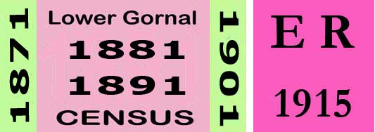
Lower Gornal District
1851 Enumeration District: 12 Lower Gornal.
Boundary of Enumeration
All the part of the Hamlet of Lower Gornal beginning with Mr Richard Marsh's Residence at Ruiton including all the Houses on the same side of the Road leading to Lower Gornal Village as far as the Waggon & Horses Inn including all the Houses on the same side adjacent thereto and proceeding by the field Road to and taking Stickley House, the Ellowes Cottage, the Ellowes House and the Old Abbey and from that end of the Lane near Stickley House proceed in a straight line to the corner of Turners Hill continuing down the right hand fence thereof to the Brook course in continuation therewith & the Old Stone Quarry through Botany Bay to Mr Richd. Marsh's House omitting those Houses at Botany Bay & betwixt that place & the aforesaid House.
Notes:
1851 Enumeration District: 13 Lower Gornal.
Enumerator: Mr Edward Oakley
Boundary of Enumeration
All that part of the Hamlet of Lower Gornal beginning at the opposite corner to the Waggon and Horses Inn, on the same side of the road including all the houses to the last in Smout's Holloway then returning by taking the opposite side thereafter including the Parsonage, and all that space of land lying on the left hand side of the Fields Road, from the Waggon and Horses Inn past Stickley House to the end of the lane thence in a straight line to the corner of, and including Turners Hill thence down the remaining fence of Hill Piece, and Sand pit leasow, to the top of Musk Lane, excluding all the dwellings betwixt the top of Musk Lane on the left hand side thereof through Barrs Meadow, to the last house in Smout's Holloway, including also that space of land lying on the left hand side of the lane from Smout's Holloway to the (Old Abbey excluded) and omitting those houses on the left hand side of the road from the Old Abbey in continuation therewith past the Church to the Parsonage House.
1851 Enumeration District: 14 Lower Gornal.
Enumerator: Mr Joseph Beale
Boundary of Enumeration
All that part of the Hamlet of Lower Gornal beginning at the first House in the opposite side of the Road to the late Mr Isaac Thomson's Farm House, and including all the houses on that side of the Road as far as Jones' Lane, taking all of those Houses on the North side of that Lane to the top thereof, exclusive of Mr Ritson's Farm House, and thence as a Boundary back from Jones Lane, the left hand side from the western fence of Mr Ritson's Garden to the Pond at the Corner of the Holloway Piece, and on a straight line to the opposite Corner to the Crown Inn at Ruiton, Returning down the Road to the House first started from.
Notes:
The Crown Inn
1851 Enumeration District: 15 Lower Gornal.
Enumerator: Mr Thomas Addenbrooke
Boundary of Enumeration
All that part of the Hamlet of Lower Gornal beginning at the first House on the South side by Jones' Lane in coming from Roberts Green including all the Houses on that side to the Five Ways Inn inclusive and the Curates residence opposite, thence including all the houses on both sides of the Road to the Lake as far as Abaldens?? Shop, the houses in Fiddler's Lane also, and the National School House, the Cottage opposite thereto, the Farm House opposite the Church, and thence to the first Houses in Jones' Lane started from.
Notes:
'Fiddler's Lane', an early name for Humphrey Street.
1851 Enumeration District: 16 Lower Gornal.
Enumerator: Not indicated.
Boundary of Enumeration
All that part of Lower Gornal Hamlet beginning at the first house from Roberts Green towards Deepdale bank including all the Houses on both sides of the Lane through Deepdale Bank and the Grave Yard to Coopers Bank Toll Gate House inclusive, including any Cottages in the Colliery lying betwixt Deepdale Bank and the Grave Yard returning from the Toll Gate at Coopers Bank to Roberts Green by the left hand side of the Dudley Road till arriving at the place where the Brook course crosses the said Road and thence in continuation with the Brook as far as the South Fence of Bradleys Meadow the right hand fence of the Upper Leasows and the adjoining piece belonging to Lord Dudley's Trustees into Deepdale Lane and from the said Lane by the right hand fence of the Duke's Piece part of the Lower Dukes and the three cornered piece to Roberts Green.
Notes:
~
Upper Gornal District.
1851 Enumeration District: 6 Upper Gornal.
Boundary of Enumeration
All that part of Upper Gornal beginning at Mr J. M. Ballenden's Residence on the Dudley Road, including all the houses on the Eastern side thence as far as Quarry House inclusive, and within the Boundary at the back of Mr Ballenden's House formed therefrom by the North fence of the Ox Piece and the Long Innage thence to the North fence of the Cow pasture, the Lower Meadow, and Wet Meadow, returning thence on a Straight line by the Field Road leading into the Dudley Road entering the same at the corner of Quarry House Garden, and all the Houses on the Western side of the Road hereafter? the said Mr Ballenden's House as far as the one lately occupied by Mrs Eagleton School Mistress leaving the corner of the said dwelling and keeping on the right hand side of the Road leading down to the Bull & Butcher Inn including all houses on both sides of the road leading from the Inn, Moden Hill, Botany Bay and all those houses at Moden Hill to the right of the one lately occupied by Mr John Payne, and those within the Boundary extending from Botany Bay down the North side of the Old Stone Quarry and Spring piece to the Ellowes Carriage Road which continues the Boundary to Paynes House, turning the corner thereof down the South fence of Darbey's Hill and the Lower Furlong to the Upper Furlong leading to the left by the East fence of the Lime Pit piece to the Cotwall End Road keeping the right hand side thereof to the Catholic Chapel and the right hand side of the Road to Mr Ballenden's House.
Notes: 
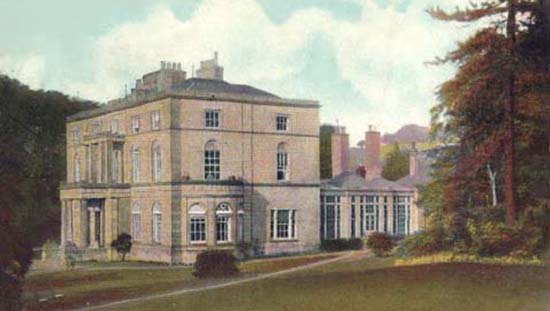
'Mr' [Dr] John McNab Ballenden was born in Stromness, Orkney in 1813, he studied medicine in Edinburgh and moved to Sedgley soon after qualifying around 1850, he took up residence at Bleak House, a prominent Georgian style building on the Dudley Road, he served Sedgley and district until his death in 1895. During the 20th Century Bleak House became an Infant Clinic, it was demolished in the 1960s.
Ellowes Coach Road Bull and Butcher Inn
1851 Enumeration District: 7 Upper Gornal.
Boundary of Enumeration
All that part of the Hamlet of Upper Gornal beginning at Mr Will'm Hills Swan Inn and including all those Houses on the same side of and in continuation with the Road leading past the Ruiton Independent Chapel including the Cottage opposite thereto and finishing at the last House in Hermit Row including all the back Houses situate within the Boundary of the said Road and from the last visited taking the Field back to the Swan Inn, omitting Mr Sam'l Saunders' House, the Chapel etc., Club Row etc.
Notes:
The Swan Inn was located in Mount Street.
1851 Enumeration District: 8 Upper Gornal.
Boundary of Enumeration
All that part of the Hamlet of Upper Gornal from Mr Wm. Hills Swan Inn exclusive & down the Dudley Road as far as the Britannia Inn (inclusive) turning the corner of the said Inn to and including the Club Row, the Methodist Chapel and Mr Samuel Saunders House there turning to the left and including all the Houses to the last in the Square, thence into Pail piece taking both sides thereof and finishing at the last of Mr Wm. Heldon's four Houses.
Notes:
The Swan Inn was located in Mount Street.
1851 Enumeration District: 9 Upper Gornal.
Boundary of Enumeration
All that part of the Hamlet of Upper Gornal beginning at the Britannia Inn taking in all the houses at the back as far as those adjoining up to the road which passes the Square from the Club Row thence including the whole of the Houses on the right hand side of the road leading to Dudley as far as Jews Lane and all the Houses on the right hand side of that Lane to and including Cricket Meadow, Mr John Ritsons Farm and all within the boundary of Upper Gornal in a straight line to the opposite corner to the Crown Inn at Ruiton returning thence to the place started from excluding any dwelling on the road side from Ruiton passing the Pale Piece to the Dudley Road.
1851 Enumeration District: 10 Upper Gornal.
Boundary of Enumeration
All that part of the Hamlet of Upper Gornal beginning at the House lately occupied by Joseph Waterfield on the opposite side of the Road to the Britannia Inn including all the houses on that side of the road as far as Eve Lane, the Innage, the Parsonage and those few dwellings on the same side at Goosey Green at Mr Cartwrights Malthouse and any other within that compass of land from Mr Joseph Waterfields House to Goosey Green and thence to the East fence of that piece of land belonging to William Ashcroft, and the adjoining next meadow turning to the left up the North fence of the Lower Meadow on a straight line therefrom to the Dudley Road entering the same at the corner of Quarry House garden opposite the house lately occupied by Mrs Egglington [sic]and thence down the road to the place started from.
Notes:
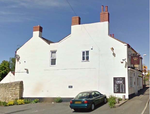
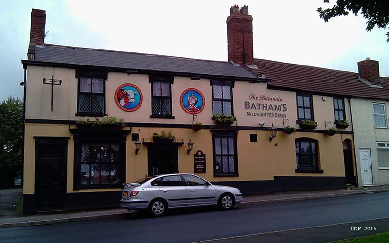
"Mrs Egglington" or was this Mrs Eagleton", residence was Prospect House. later occupied by Mrs Bradley.
Britannia Inn.
1851 Enumeration District: 11 Upper Gornal.
Boundary of Enumeration
All that part of the Hamlet of Upper Gornal commencing at E.P.Cartwrights including all the Houses on the right hand side of the Road towards Dudley as far as Shavers End, taking in the City, Mr Smith's house and those adjacent including those also at Shavers End to the one situate at the corner of the Deepdale Lane being opposite to that occupied by W Fellows (formerly occupied by Wm. ?Webb?) House, any others within the boundary formed by the South fence of those pieces of land known as Bavis Meadow and Hollow Meadow to the Brook course continuing therewith to the North fence of Jockey Hateley's piece thence up the North fence of Badleys Meadow and the Plain Under Hill into the Lane continuing the Boundary from the Lane at the Foredrove to the North fence of the Lower & Upper Dukes, the West fence of Lower piece and the North fence of the Croft, to those Houses known as Roberts Green (inclusive) being opposite Mr Ritson's Farm House including also all the Houses thence on the right hand side up Jews Lane to Mr Cartwrights.
Notes:
'Badleys' Meadow was changed to Bradleys Meadow in 1861 description.
~